|
Polymap 
|
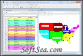
Easily create thematic maps. PolyMap is an easy-to-use desktop mapping and geographic presentation software package for Windows 7 / Vista / Windows XP / 2003 to create thematic and informative maps for presentations. Large corporations, small businesses, independent consultants, scientists, Geo-analysts and numerous government agencies are discovering important informations in their data withPolyMap.
PolyMap makes the process of composing maps easier by giving you a flexible and simple work environment. Use the buildt in spreadsheet to enter data or paste them from other Windows applications. PolyMap provides a rich set of features for displaying and printing maps, and in particular for making the appearance of the map dynamically dependent on data. Use the Map Presentation Wizard for a step-by-step process to customize your map and the map's legend. An easy-to-use labeling feature included in PolyMap offers you to use any spreadsheet column data for labeling.
Polymap Features:
1. Layer control
2. Multiple Zoom levels
3. Dot density presentation
4. Thematic shading
5. Graduated symbols
6. 3D prisms
7. Pie and bar charts
8. Portfolio Thematic mapping
9. Text labeling
10. Text positioning
11. Shading Wizard
12. Print Preview
13. Drawing tool
14. Map to Web link
15. Radius Selection
16. Send map by e-mail
17. Export to BMP, JPG, GIF, PNG and EMF
18. Data import Wizard
19. Distance measurement
Working with Maps and Data
Use a set of geographic layers in different formats - state and county boundaries, five-digit ZIP codes, US and state highways, cities, rivers, lakes - to add details and to create your new thematic map.
Add custom points to the map
First time using this command PolyMap creates a new custom map point layer. If you choose Add Point from the map toolbar, PolyMap displays the Add Point dialog box, which inserts the new point in the map and adds a new line in the point spreadsheet.
Clipboard format Enhanced Metafile included
You can select the Enhanced Metafile format to copy the map window to the windows clipboard. You can paste the map to any application that supports the Enhanced Metafile format.
Map export format PDF
PolyMap allows you to create Portable Document Format (PDF) files directly from the map window.After the files are converted to Adobe PDF, you can view them using Adobe Acrobat or Acrobat Reader.
Map print preview feature
The Print preview lets you control your map print output. Full page, Page Width, Header, Footer and zoom factor set by the user are supported.
Print out your work
PolyMap prints the maps and spreadsheets on any Windows-compatible printer.
Map export to Enhanced Metafile
You can export your maps with all features to an Enhanced Metafile. Metafiles are the standard method of exchanging vector graphics (i.e. drawings composed of objects) among Windows programs.
Customize maps and layers
You can hide or delete layers from a mapset. Selected objects in the map window or selected rows in the spreadsheet can be deleted using the Edit Delete command.
Automatic selection between map and spreadsheet
To select a number of objects from a map click on the desired objects with the Select tool. Do this operation as often as you want.
Limitations:
* Only a few sample maps are included
The license of this software is Free Trial Software, the price is $89.95, you can free download and get a free trial.
